
DroneEye AR Piloting System: Next-Generation Spatial Teleoperation & BVLOS Heads-Up Display
Eliminate screen-bound latency and cognitive fatigue. The DroneEye AR Piloting System integrates real-time UAV flight telemetry, thermal streams, synthetic horizons, and tactical waypoint overlays directly into the pilot's line of sight on ThirdEye X2 MR Smart Glasses—unlocking unmatched situational awareness for defense, public safety, and critical infrastructure inspections.
Solving the "Head-Down" Dilemma in UAV Operations
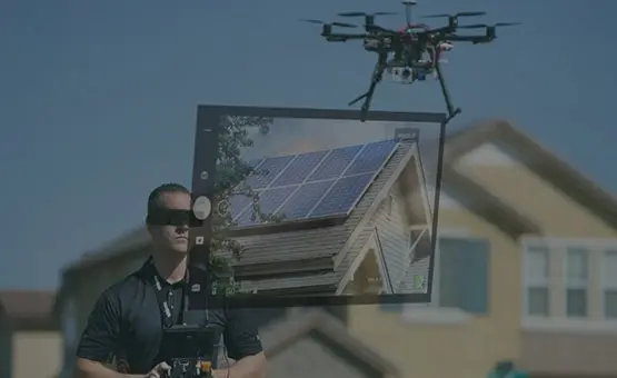
For over a decade, commercial and defense Unmanned Aerial Vehicle (UAV) operators have been constrained by legacy Ground Control Stations (GCS). Traditional handheld controllers, tablets, and field laptops demand a constant "head-down" posture. This operational paradigm creates critical vulnerabilities: loss of direct line-of-sight visual contact with the aircraft, spatial disorientation in complex low-altitude environments, severe neck fatigue, and diminished peripheral hazard detection.
The DroneEye AR Piloting System, developed natively for the ThirdEye X2 MR Smart Glasses, fundamentally transforms UAV command and control. By projecting high-refresh-rate flight telemetry—including airspeed, altitude, synthetic horizon lines, battery health, GPS coordinates, and payload sensor streams—directly over the physical environment, pilots achieve true heads-up, hands-free spatial awareness.
- Zero-Latency Optical Waveguide Overlay: Maintains clear visibility of the aircraft while reading crisp telemetry data.
- BVLOS Enhanced Safety: Synthetic spatial bounding boxes keep track of the drone even behind terrain or structures.
- Dual-Stream Sensor Visualisation: Toggle instantly between optical RGB, FLIR thermal, and spatial point-cloud layers.
- NATO & Enterprise Protocol Compliance: Full integration with MAVLink, PX4, ArduPilot, and proprietary defense APIs.
Recommended Hardware & Software Ecosystem
Global procurement teams demand vertically integrated solutions. ThirdEye Gen provides the complete hardware tier, spatial AR operating system, and cloud-to-edge management stack.
1. DroneEye AR Piloting System
The flagship software platform designed specifically for spatial UAV guidance. Features dynamic waypoint plotting, thermal overlay, target lock tracking, and voice-commanded sensor management built on an optimized Android spatial rendering engine.
Request Software Spec Sheet →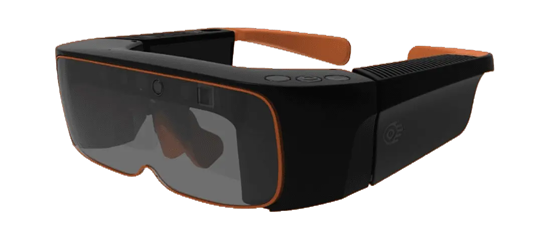
2. ThirdEye X2 MR Smart Glasses
The premier standalone mixed reality headset engineered for tough enterprise environments. Weighing under 300 grams with dual daylight-readable optical waveguides, hot-swappable batteries, integrated SLAM sensors, and an open Android SDK for custom integration.
Explore X2 Hardware Specs →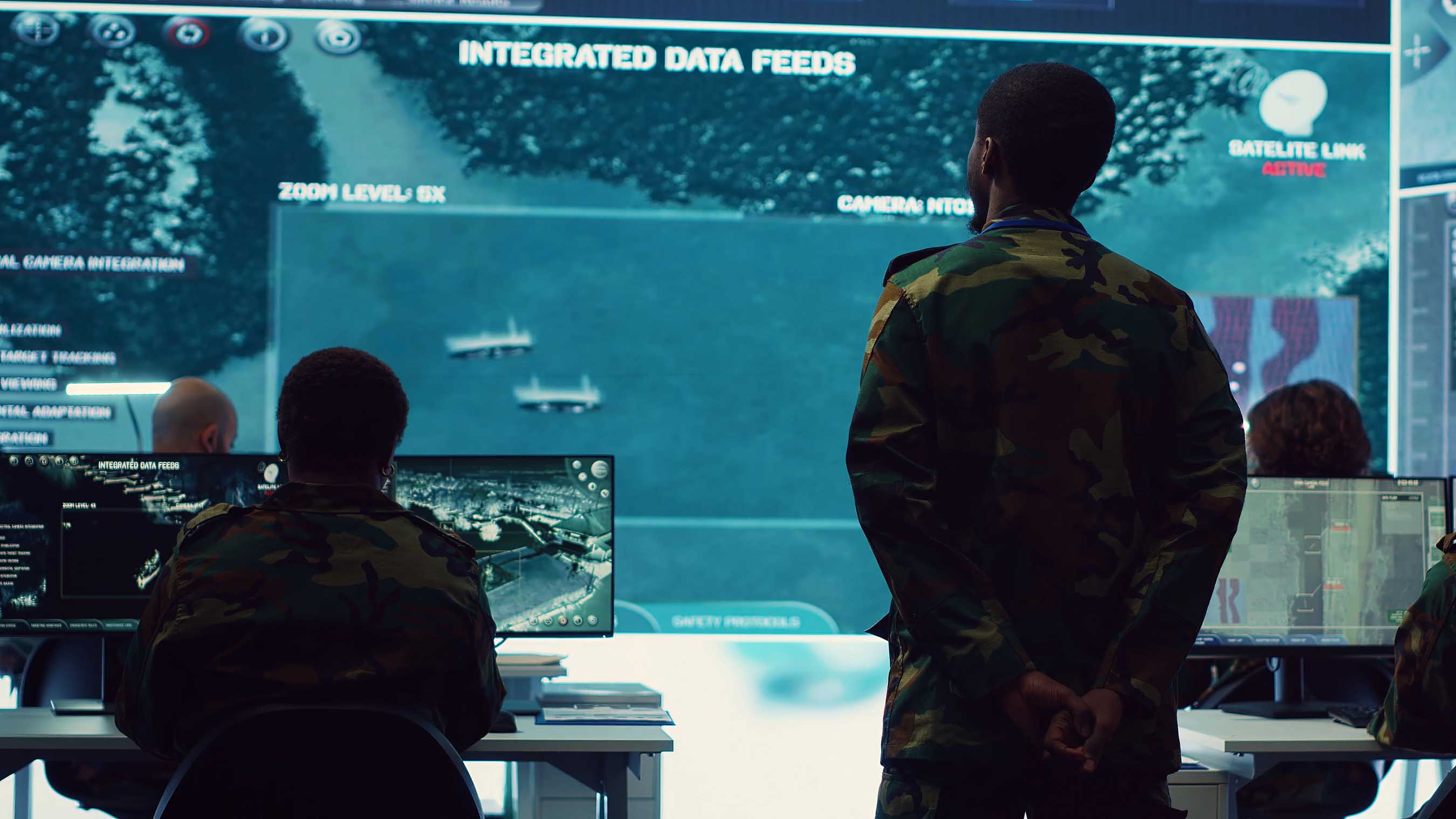
3. Command Center Platform
Enterprise command node streaming live UAV video, pilot telemetry, geolocation markers, and AR annotations across multiple field units simultaneously. Connects remote commanders directly with front-line drone operators in real time.
View Command Center Platform →DroneEye & X2 Hardware Technical Matrix
Evaluated under strict military and industrial performance criteria to ensure continuous operation in challenging environments.
| Performance Category | Technical Specification | Operational Advantage |
|---|---|---|
| Display Technology | Dual 720p See-Through Optical Waveguides (42° FOV) | Provides crisp heads-up graphic overlays without obscuring the pilot's visual line of sight to the UAV. |
| Processor & OS | Qualcomm Snapdragon XR Compute Platform, Open Android OS | On-board processing eliminates backpack PCs, allowing low-latency spatial rendering directly on the smart glasses. |
| Flight Controller Sync | MAVLink v2.0, PX4, ArduPilot, DJI Mobile SDK v4/v5 | Plug-and-play interoperability with 90%+ of global enterprise and defense drone platforms. |
| Wireless & Latency | Wi-Fi 6, 5G Cellular Dongle Support, Ultra-Low Latency RTSP (<40ms) | Ensures real-time tactical video streaming from the drone payload directly to the pilot's smart glasses. |
| Security Architecture | SXR Air-Gapped Engine, AES-256 Bit Encryption, ITAR-Aware | Protects sensitive telemetry feeds from interception during secure military or critical asset operations. |
| Power Management | Dual Hot-Swappable 1750mAh Batteries, Continuous Runtime | Allows continuous field operation during extended drone search-and-rescue or power grid inspections. |
Global Procurement Trends in AR UAV Teleoperation (2025–2030)
As international defense agencies, energy conglomerates, and public safety entities upgrade their robotics infrastructure, five decisive procurement trends are shaping tender specifications worldwide.

1. Mandated BVLOS Visual Safety
Aviation authorities (FAA, EASA, CASA) are accelerating Beyond Visual Line of Sight (BVLOS) approvals. Tenders increasingly mandate heads-up AR displays that project synthetic spatial bounding boxes around the drone, keeping operators compliant with visual observer rules.

2. Edge-AI Feature Extraction
Modern procurement contracts favor platforms that combine AR smart glasses with computer vision at the edge. DroneEye overlays real-time thermal anomaly identification, structural flaw bounding boxes, and object classification tags directly over the live stream.

3. Zero-Trust Air-Gapped Security
Geopolitical tensions have heightened cybersecurity requirements. Buyers reject cloud-dependent AR setups in favor of on-device, air-gapped systems like ThirdEye’s SXR architecture, which run without sending sensitive geographic telemetry over public servers.
4. Cross-Domain Multi-UAV Swarms
Future tenders focus on single-operator control of autonomous multi-drone swarms. DroneEye’s spatial HUD allows pilots to monitor multiple aircraft paths simultaneously on a dynamic AR compass, reducing crew size and operating overhead.
5. Unified Remote Expert Telepresence
Enterprise drone inspections require fast decision-making. By coupling DroneEye with ThirdEye’s RealEye AI Telepresence, field drone pilots can stream their heads-up AR view directly to off-site structural engineers for instant sign-offs.
6. Open Platform Interoperability
Silos are disappearing. Buyers avoid locked-down, proprietary hardware ecosystems. ThirdEye’s commitment to an open Android OS and documented SDKs ensures seamless integration with custom enterprise GIS and ERP backends.

Engineered for Defense, Validated by the US Air Force
ThirdEye Gen’s hardware and software platforms have undergone rigorous testing in demanding operational environments. Awarded a prestigious US Air Force AR Headset Contract, ThirdEye has demonstrated its capacity to deliver secure, resilient spatial computing solutions for military aviation, airfield logistics, and tactical unit deployment.
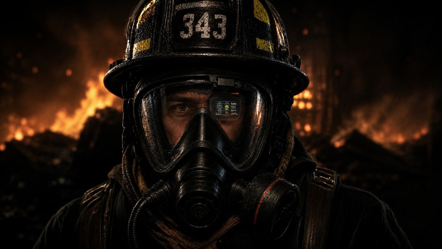
When combined with the MIDAS AR Display Mask or configured on tactical defense headsets, the DroneEye system enables drone reconnaissance in compromised environments where atmospheric smoke, dust, or CBRN threats prevent normal operation.
- Built to withstand extreme temperature ranges and dust exposure.
- Compatible with tactical helmets, gas masks, and protective eyewear.
- Integrated with ThirdEye SXR for classified tactical network sync.
Enterprise Value & Operational ROI Model
Deploying the DroneEye AR Piloting System on ThirdEye X2 MR Smart Glasses yields quantifiable cost reductions across field service operations, structural inspections, and public safety missions.
AR UAV Fleet Deployment ROI Model
Financial calculations are based on average industry labor costs, eliminated secondary visual observer requirement, reduced accident rework, and faster inspection cycle times. Internal customer audits confirm up to 60% faster mission execution during aerial asset inspections.
DroneEye AR Piloting System FAQs
Answers to common questions from enterprise procurement officers, system integrators, defense program managers, and technical specialists evaluating DroneEye technology.
1. What is the DroneEye AR Piloting System and how does it function on ThirdEye X2 MR Glasses?
The DroneEye AR Piloting System is an enterprise-grade spatial software application designed specifically for the ThirdEye X2 MR Smart Glasses. It connects wirelessly to commercial and military UAV flight controllers via MAVLink or custom SDKs, rendering real-time heads-up flight instruments (airspeed, altitude, synthetic horizon, pitch/roll, heading, battery life) directly within the pilot’s field of view. By overlaying HD video and thermal imaging onto daylight-readable see-through optics, pilots keep continuous visual contact with the sky while concurrently monitoring payload streams and spatial data hands-free.
2. How does DroneEye enhance Beyond Visual Line of Sight (BVLOS) UAV flight operations?
During BVLOS operations, maintaining spatial awareness is challenging. DroneEye addresses this by rendering dynamic 3D synthetic terrain contours, air corridor geofences, and projected trajectory lines directly on the smart glasses. If the aircraft passes behind structures, dense canopy, or terrain, DroneEye’s spatial engine maintains a 3D bounding box indicating the drone’s precise geometric location relative to the pilot, significantly enhancing flight safety and regulatory compliance.
3. Can DroneEye operate in classified, air-gapped, or GPS-denied tactical environments?
Yes. DroneEye is fully integrated with ThirdEye’s Secure Extended Reality (SXR) software framework. SXR provides complete local data processing on the X2 Smart Glasses’ Snapdragon platform, eliminating the need for an active cloud link or external Internet connection. Telemetry and video streams are secured using AES-256 bit encryption, allowing defense agencies and critical utility operators to deploy DroneEye in electronic warfare (EW) environments, GPS-jammed regions, or strict air-gapped military networks.
4. What flight controllers, drone platforms, and wireless protocols are natively supported?
DroneEye natively supports open-standard MAVLink v1/v2 telemetry protocols, making it instantly compatible with PX4, ArduPilot, and commercial drone platforms based on these stacks. Furthermore, customized software connectors are available for DJI Mobile SDK (v4/v5), Autel Enterprise, and proprietary defense UAV platforms. Video feeds can be ingested via low-latency RTSP, WebRTC, or direct HDMI-over-USB-C hardware adapters.
5. How does the system perform in direct sunlight during outdoor field operations?
The ThirdEye X2 MR Smart Glasses utilize high-brightness optical waveguides engineered for daylight readability. For extreme high-glare environments, such as desert operations, maritime flight decks, or snow-covered search areas, ThirdEye provides snap-on protective neutral density (ND) sun-shields and polarized visors, ensuring that heads-up AR flight data remains sharp and legible in all lighting conditions.
6. How does DroneEye connect with the ThirdEye Command Center Platform?
While the local drone operator views heads-up telemetry on the X2 Smart Glasses, DroneEye simultaneously broadcasts a low-bandwidth feed back to the central ThirdEye Command Center. Remote commanders, incident leaders, or chief engineers can view real-time flight telemetry, pilot position, and live payload video on a centralized GIS map interface. Remote personnel can also place spatial AR markers onto the pilot's HUD display to highlight targets or hazardous obstacles.
7. What are the key enterprise application areas for DroneEye beyond military defense?
DroneEye is widely deployed across multiple high-stakes sectors: Energy & Utilities (high-voltage power line and wind turbine inspections), Oil & Gas (flare stack and pipeline thermal monitoring), Public Safety (first responder tactical situational awareness and search-and-rescue), Construction & AEC (real-time BIM overlay onto aerial site maps), and Environmental Management (wildfire perimeter tracking).
8. How does ThirdEye support software developers and system integrators seeking custom features?
ThirdEye provides an open Android SDK, comprehensive REST APIs, and developer support for the X2 MR Smart Glasses. System integrators can customize DroneEye's user interface, incorporate proprietary computer vision algorithms, bind custom telemetry channels, or develop tailored AR workflows accessible directly through the ThirdEye Developer App Store.
9. What training is required for flight crews transitioning from traditional GCS tablets to AR glasses?
Because DroneEye mirrors standard flight instrument layouts (PFD - Primary Flight Display standards) in a clean heads-up format, most certified UAV pilots adapt quickly. Field evaluation trials indicate that pilots achieve operational proficiency within 2 to 4 flight hours, citing reduced neck strain and simplified multitasking as primary operational advantages.
10. How can international buyers request pricing, technical evaluations, or hardware demonstration units?
Procurement departments, program leads, and authorized distributors can initiate an evaluation request by clicking the Get Catalog button on this page. ThirdEye Gen provides comprehensive technical specifications, commercial quotation matrices, software licensing documentation, and global shipping logistics through our worldwide partner network.
Why Global Leaders Partner with ThirdEye Gen Inc.
Headquartered in Princeton, New Jersey, ThirdEye Gen brings nearly a decade of hardware engineering, software development, and global logistics experience to high-stakes defense and enterprise spatial deployments.
US Air Force Contract Holder
Recipient of competitive US Air Force contracts, demonstrating that ThirdEye hardware and software meet stringent security, reliability, and human-factors standards required by military aviation authorities.

Princeton R&D Hub
Located in Princeton, NJ, our core optics labs and spatial computing software teams collaborate with top research institutions to advance waveguide design, thermal imaging sync, and AI object tracking algorithms.

5G Carrier & FirstNet Validated
ThirdEye platforms are tested and certified across premier telecom networks, including Verizon, T-Mobile, and AT&T FirstNet, ensuring robust, low-latency video streaming for tactical field operations.

Request the Full DroneEye AR Specifications & Enterprise Catalog
Equip your flight crews with heads-up spatial situational awareness. Speak with our application engineers, request full technical data packages, or order an evaluation unit for your fleet today.